UNESCO names 16 new Global Geoparks
Today, UNESCO designated 16 new geoparks, bringing the total number of sites in the UNESCO Global Geoparks Network to 229 in 50 countries. The network now covers an area of almost 855,000 km², equivalent to the size of Namibia.

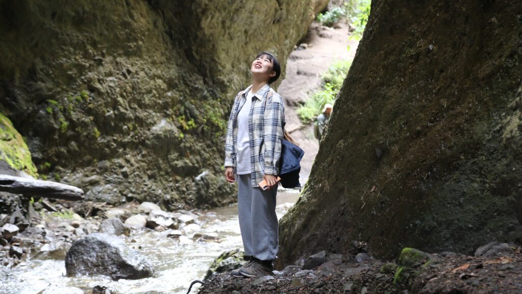
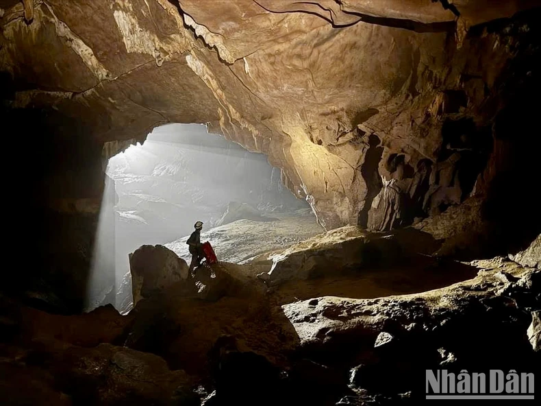
Mr. Mohamed Imran Abid / North Riyadh Geopark, Saudi Arabia
17 April 2025
The UNESCO Global Geoparks Network, which this year celebrates its 10th anniversary, brings together territories recognized for their rich geological heritage – rock formations, mountain or volcanic ranges, caves, canyons, fossil sites or ancient desert landscapes – which bear witness to our planet’s history, evolution and climate. These sites are also places for conservation and environmental education, where local and indigenous communities can promote their culture and know-how.
In ten years, UNESCO Geoparks have become models for the conservation of geological heritage. But their role goes much further: they support educational projects, promote sustainable tourism and keep the knowledge and traditions of these territories alive through the active participation of local and indigenous communities. This is the case, for example, in Iceland’s Katla Geopark, where local schools are actively involved in the scientific research that is carried out on this landscape, which preserves the memory of volcanic and glacial systems through its lava flows and black sand beaches.

Audrey AzoulayUNESCO Director-General
Each year, new sites are added to the network by decision of UNESCO’s Executive Board, after an evaluation of the applications by the Global Geoparks Council, made up of international experts.
The 16 newly designated geoparks are located in China, Democratic People’s Republic of Korea –marking its first geopark and contribution to the protection of the shared mountain range with China –, Ecuador, Indonesia, Italy, Norway, Republic of Korea, Saudi Arabia — hosting its first two geoparks —, Spain, United Kingdom and Viet Nam.
UNESCO continues to promote the programme in areas where geoparks are less common, notably in Africa, the Arab States and Small Island Developing States. UNESCO does this by facilitating expert missions, tailored training sessions and individual consultations on both a national and local scale, to guide the preparation of applications for UNESCO Global Geopark status.
The new UNESCO Global Geoparks are:
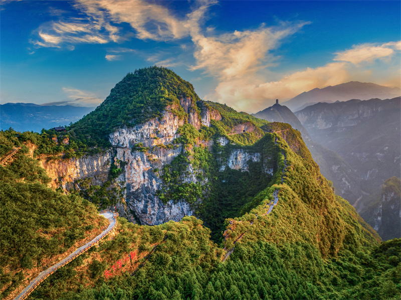
China: Kanbula UNESCO Global Geopark
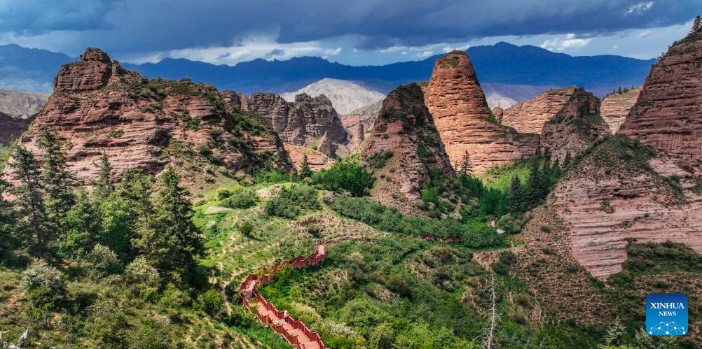
Kanbula UNESCO Global Geopark, located on the northeast margin of the Qinghai-Tibet Plateau, is home to remarkable geological features shaped by complex processes. Highlights include the Maixiu volcanoes – a group of exceptionally well-preserved ancient volcanoes – and the Yellow River, the sixth longest river in the world. While the geopark works to preserve this rich geological heritage, it also plays a vital role in protecting local communities from river-related risks, coordinating warning systems and forecasts, and raising awareness on how to respond to flooding and landslides.
Culture and tradition are deeply rooted in Kanbula’s landscape, where scientific approaches are enriched by ancestral Tibetan heritage. At the 14th-century Longwusi Monastery, a traditional Tibetan Thang-ga mural tells the story of Earth’s evolution – depicting the rise of mountain peaks, volcanic eruptions and the arrival of oceans. Humans and animals are interwoven throughout, and this mural reflects cultural beliefs in a harmonious coexistence with nature – a theme that resonates deeply with local communities. Blending scientific explanations with cultural narratives is central to the geopark’s work. Combining tradition with local economic development, the geopark supports community initiatives such as the Sangjie Thang-ga Art Academy, a cooperative that revitalises traditional Thang-ga skills while empowering women from rural communities through training and sustainable employment.
China: Yunyang UNESCO Global Geopark
Yunyang UNESCO Global Geopark, located in southwest China, showcases landscapes shaped nearly 250 million years ago that record the disappearance of an inland sea and the unique terrestrial environment that emerged in its place. The region is best known for its dinosaur-rich fossil deposits and is home to the remarkable ‘Great Wall of Dinosaur Fossils’, an 18 km stretch of rock layers packed with fossils dating back nearly 170 million years. In one extraordinary section, around 5,000 dinosaur fossils are exposed offering unique insights into dinosaur evolution during the Middle Jurassic. The geopark is also home to dramatic karst landscapes – distinctive rock formations shaped by water over time – including one of the world’s deepest sinkholes, which plunges 335 meters and serves as a key research site.
Yunyang UNESCO Global Geopark has a rich cultural history spanning over 2,300 years, with temples, traditional villages and fortresses strategically positioned along the Yangtze River. The geopark is home to the Tujia ethnic group, who have sustained distinctive traditions including root carving, brocade weaving and waving dances. To ensure these traditions thrive, the geopark works with local communities to support the production and sale of handicrafts, while local schools have incorporated lessons that teach these traditions to younger generations. Events such as the Tujia Daughters’ Meeting and cultural art exchanges provide local communities with opportunities to share their heritage and engage in the geopark’s development.
Democratic People’s Republic of Korea: Mt Paektu UNESCO Global Geopark
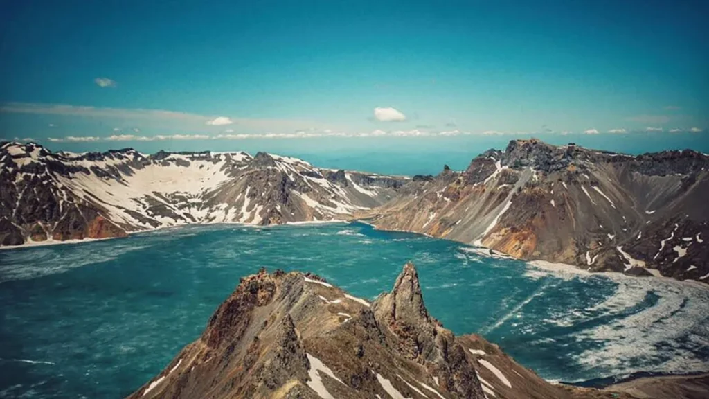
Mt Paektu UNESCO Global Geopark is marked by a fascinating geological legacy, with spectacular landscapes shaped by volcanic eruptions and glacial erosion. It is the first UNESCO Global Geopark to be nominated in the country. Mt Paektu sits at the heart of the geopark and is a key site for understanding volcanic activity. It was the location of one of the largest eruptions in recorded history – the Millennium Eruption in around 1000 CE – which spread volcanic ash as far as Japan and created extraordinary geological features, including Lake Chon, a striking caldera lake that sits at 2,190 meters above sea level. The aftermath of the eruption is vividly preserved in the landscape. Hot springs, carbonised trees and rising magma channels in the Janggun Peak laccolith offer a rare glimpse into different stages of volcanic eruptions. Today, geophysical research continues to monitor Mt Paektu’s volcanic zone where magma chambers and gaseous emissions hint at ongoing activity.
For centuries, Mt Paektu has been celebrated as an ancestral mountain, a symbol of dignity with deep spiritual and cultural significance. This reverence is reflected in centuries of poetry and travel writings, including works such as Pounjib (1533), Chongguyongon (1727) and Kwangokjib (1895).
Today, this cultural legacy is actively preserved and shared by local residents. The area is also home to enduring traditions such as the “Arirang” folk song, and food customs centred on potato starch – a reflection of the community’s adaptation to the region’s cold, mountainous climate, where temperatures average -0.6°C annually and can fall as low as -19.8°C in January.
Ecuador: Napo Sumaco UNESCO Global Geopark
Napo Sumaco UNESCO Global Geopark is located in the heart of Ecuador’s Amazon Basin, where the Andean mountains meet the Amazon plains. The geopark showcases over 170 million years of geological activity, from the Jurassic period to the present day. Highlights include Sumaco Volcano, a striking and potentially active volcano with a rare composition, and karst formations, where researchers study climate change through speleothem (cave formation) analysis. The area is not only geologically significant but also known for its rich biodiversity, home to over 6000 plant species and a variety of rare animals, many of which are found nowhere else.
Local communities play an active role in protecting and maintaining the geopark’s geological sites, carrying forward the Indigenous Kichwa concepts of minga and turkana. Pacha Mama (Mother Earth) is central to the Amazon Kichwa people’s value system, preserved as valuable ancestral knowledge that connects geodiversity, biodiversity and culture. Many geosites can only be accessed with the guidance of local residents, ensuring respectful land use while providing opportunities for local communities. Several community groups contribute to the geopark’s activities: the Pushak Runakunas Guides promote geotourism and the conservation of natural attractions, and the Yachak Awakkuna collective specialises in traditional crafts such as ceramics, natural pigment painting, fibre art, and handmade costume jewellery featuring seeds and mullos, which are key elements of Amazonian attire. The Mikusha Kawsari Gastronomic Group highlights the importance of the Amazonian agroecological chakra system, showcasing its role in food production and natural medicine, while also bringing a gourmet twist to traditional Amazonian dishes.
Ecuador: Tungurahua Volcano UNESCO Global Geopark
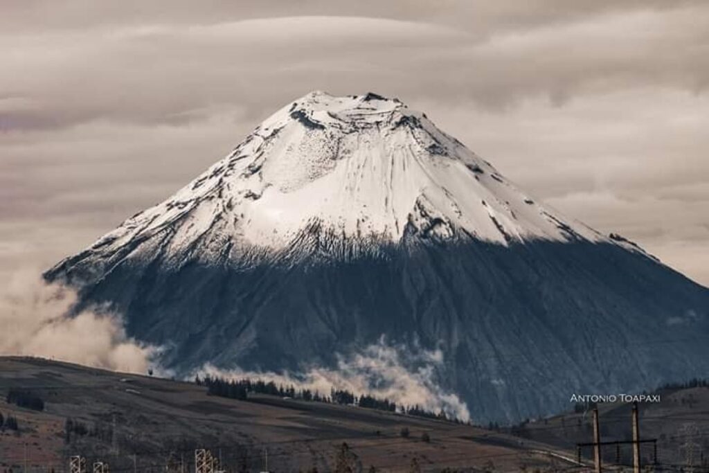
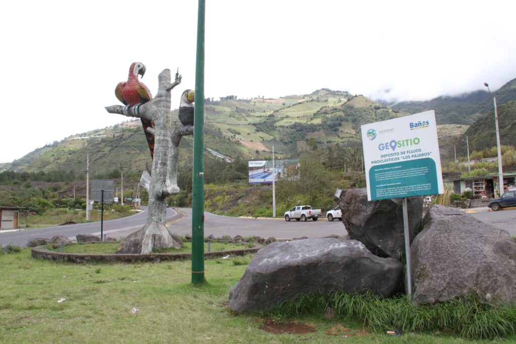
Located in the Ecuadorian Andes, Tungurahua Volcano UNESCO Global Geopark displays a geological history spanning over 417 million years, shaped by volcanic eruptions and glacial activity. The landscape features deep canyons, crystal-clear rivers, icy waterfalls and towering rock walls. At the centre stands Tungurahua Volcano, an active site for volcanological studies. Beneath its surface, magma heats underground water, creating mineral-rich thermal springs that have long been valued for their therapeutic properties. The geopark also has a significant seismic history, with major earthquakes in 1797 and 1949 devastating towns like Guano, Pelileo and Patate. Baños de Agua Santa, located at the foot of Tungurahua Volcano, endured eruptions from 1999 to 2016 and has been recognized as a model for resilience in the face of volcanic events. Today, the town thrives with diversified economic activities, including a well-developed adventure tourism industry.
The geopark spans five municipalities–Baños, Patate, Pelileo, Guano and Penipe–and the prefectures of Tungurahua and Chimborazo. The cultural richness of the region is reflected in the traditions of the Indigenous Salasaca and Puruhá peoples, who have preserved their identity through distinctive clothing, music, dance and ancestral storytelling. The connection between geology and culture is visible in innovative sustainable development initiatives. One standout example is the GeoAmigo Cafeteria “Casa del Volcán”, owned by local resident Indira Medina. This cafe celebrates local identity and cuisine with a volcanic theme inspired by Tungurahua, sourcing ingredients from farmers in the region, and serving ancestral dishes. Another example is the Las Caras Tourist Complex, where visitors can discover petrified tree roots and faces carved by the ancestral Killuyakus people. Discovered following volcanic activity in 2006, the site now offers educational tours, horseback riding and volcanic mineral mud treatments, all run by local residents.
Indonesia: Kebumen UNESCO Global Geopark

Kebumen UNESCO Global Geopark offers a remarkable record of Earth’s geological past, showcasing the oldest rock formations on the island of Java. A key feature is the Karangsambung site, a natural laboratory of oceanic and continental margin rocks dating back tens of millions of years. These rocks illustrate plate tectonic theory, showing how an ancient ocean floor was pushed up to the surface. The area reveals fossils from ancient marine and prehistoric ecosystems, as well as fascinating caves and underground rivers.
The geopark plays a vital role in environmental preservation and awareness raising, as well as sustainable development. One such initiative is the turtle conservation station at Jogosimo, Tambak Mulyo and Lembu Purwo Beach, where eggs, previously at risk from egg hunters, are moved to secure places for hatching. The Pandanus leaf plays a key role in the region’s cultural heritage, and pandan weaving, a practice passed down through generations, continues to be an important economic activity. In Wonorejo Village, the Jiemat geopark programme introduces this local wisdom to schoolchildren, teaching them how to process and weave pandanus into various items such as bags and sandals, ensuring that it remains a vital part of the community’s identity. The innovative Kebumen Youth Forum supports Pandanus leaf crafters in Grenggeng Village, with trainings in digital marketing, connecting traditional craftsmanship with a modern public. The cultural richness of Kebumen UNESCO Global Geopark is deeply embedded in Javanese traditions, crafts and cuisine, which reflect the region’s distinctive local identity. The connection between geology and culture is evident through spiritual practices, settlement patterns and agricultural methods. From the Megalithic to the Hindu-Buddhist and Islamic eras, geological factors such as the presence of groundwater and river proximity have significantly shaped cultural development in this region.
Indonesia: Meratus UNESCO Global Geopark
Meratus UNESCO Global Geopark offers a fascinating geological record of complex tectonic evolution beginning in the Jurassic period, 201 to 145 million years ago. The geopark is home to the oldest ophiolite series in Indonesia, and a significant presence of diamonds. This dynamic geological history has shaped the landscape and fostered rich biodiversity, including diverse varieties of orchids such as moon orchids and sugarcane orchids. The Bekantan long-nosed monkey, once endangered, is now the mascot of South Kalimantan Province. The geopark has played a central role in restoring mangrove ecosystems, crucial to the survival of the Bekantan species, which has led to the gradual recovery of their population.
The geopark is home to two main Indigenous groups, the Banjar and Dayak tribes, who continue to uphold their unique traditions. Trading at the Floating Market of Lok Baintan takes place on small boats called Jukung, and the Dayak Meratus tribe uses bamboo for transportation through a method called “Balanting Paring.” The Sasirangan fabric is central to the Banjar Tribe’s cultural identity, dating back to 1335–each motif and colour carries deep cultural significance. The geopark hosts an array of festivals and cultural events, including the Meratus Great Culture Carnival, Meratus Geopark Run, and floating market festivals. These celebrations provide a vibrant showcase of the region’s rich heritage.
Italy: MurGEopark UNESCO Global Geopark

Located in Italy’s Murge Highlands, MurGEopark offers a remarkable glimpse into Earth’s geological past. The region preserves a rare, stable portion of the Adriatic Plate, an ancient continental plate that sits between Africa and Europe, shaped over millions of years by tectonic forces. The landscape is marked by sinkholes, caves and “lamas”–wide furrows formed by water erosion. Two exceptional paleontological discoveries include a preserved Neanderthal skeleton encased in speleothems – mineral deposits formed in caves over millennia – and one of the world’s largest dinosaur track sites, with approximately 25,000 footprints.
The natural geological wealth of the region is intertwined with the region’s cultural heritage. Traditional stone sheep pens, known as jazzi, dry stone walls, ancient farmhouses, and tratturi (transhumance routes) reflect the deep connection between the land and its people. As one resident shares: “In this land, people have a unique way of life, shaped by a close connection between the wild and the rural.” MurGEopark fosters sustainable development and local pride through initiatives aimed at enhancing the region’s geological, natural and cultural heritage. One such initiative, the ‘Basket of the Murge,’ supports cooperatives for producers of high-quality, ecologically sustainable products that tell the story of the territory, blending its unique flavours and geology. Products include coratina olives, burrata, pecorino cheese and cardoncello mushrooms.
Once facing demographic decline, the creation of MurGEopark has brought a renewed sense of pride and optimism to local communities. Residents now feel a stronger identity, shaped by their connection to the geological history of the Adriatic Plate–an “almost lost continent.” This link between past and future is seen not only in scientific terms but as a source of cultural and regional strength.
Norway: The Fjord Coast UNESCO Global Geopark

At the westernmost point of Norway, where the majestic Sognefjord meets the rough Northern Sea, The Fjord Coast UNESCO Global Geopark offers an extraordinary landscape of islands, fjords, cascading waterfalls and the lowest-lying glacier in Scandinavia. The geopark is home to the ancient Caledonian mountain range, formed between 425 and 395 million years ago, and showcases exceptional geological exposures, including remnants of oceanic crust and volcanic complexes. Few places in the world offer a better opportunity to study the rise and fall of a gigantic mountain range within such a limited area. In more recent geological history, over millions of years, ice ages have gradually shaped the landscape, with the most recent one ending approximately 10,000 years ago.
The region’s geological history, combined with its abundant natural resources, paved the way for early human settlements along the coast, as people were drawn to the rich fishing grounds while glaciers still covered inland areas. These settlers quickly developed sustainable practices to manage the unique coastal heathlands. Today, the geopark has revived the 5000-year-old tradition of Old Norse sheep grazing and controlled heather burning, through a volunteer-led initiative that brings together residents of all generations and backgrounds. Old Norse sheep grazing plays a crucial role in maintaining the heathlands, preventing the spread of taller shrubs, and allowing rare species to thrive, including birds and insects. In a blend of tradition and innovation, the younger generation of sheep herders is incorporating GPS-controlled fence technology to guide the sheep, enhancing land management while preserving ancient grazing methods.
Republic of Korea: Danyang UNESCO Global Geopark

Located at the heart of the Korean Peninsula, Danyang UNESCO Global Geopark lies along the Baekdu Daegan mountain range and showcases remarkable geological diversity. The landscape features folds and thrusts within 1.9-billion-year-old granite gneiss, alongside layers of limestone, quartzite and sandstone, reflecting pivotal moments in the region’s tectonic evolution. Danyang is renowned for its prehistoric cultural relics, making it a key site for Stone Age research. The geopark has over 200 limestone caves, many of which were previously inhabited. The geopark’s wealth of archaeological discoveries are significant for our understanding of early human history in East Asia. The Guinsa Museum in Danyang displays ancient Buddhist manuscripts, reflecting the region’s rich spiritual history and connection to both ancient and modern Korean culture.
Today, the region’s geological sites attract visitors with activities including hiking, sightseeing and paragliding at the Republic of Korea’s largest paragliding facility, offering stunning views of the geopark’s topography. Visitors can also take cruise tours along the Namhan River to discover the landscape or take in panoramic views at the Mancheonha Scenic Observation Deck. The region is also known for its distinctive garlic variety, cultivated on limestone terraces, which has become a popular souvenir of the geopark. The geopark stands out for its dedication to education, with an annual programme that encourages students to participate in conservation activities, including environmental clean-ups around key geological sites.
Republic of Korea: Gyeongbuk Donghaean UNESCO Global Geopark

Gyeongbuk Donghaean UNESCO Global Geopark, located along the southeastern coast of Gyeongsangbuk-do, contains a wealth of geological wonders, including the spectacular Deokgu Valley with its ancient granitic rocks and hot springs. The spectacular Seongryugul Limestone Cave stretches 870 meters and is adorned with stalagmites, preserving valuable evidence of past sea levels and ancient marine environments. Among the geopark’s most celebrated and beloved sites are the Yangnam Columnar Joints. These striking rock formations were created when volcanic lava cooled and contracted, with the site showcasing rare radial and fan-shaped patterns that lie horizontally to the ground. They have become a symbol of local pride for the geopark. Lee Chang-woon, a baker from Gyeongju, created the “Yangnam Columnar Joint Bread” made with local ingredients, linking the area’s geological heritage with the community.
The region is also incredibly rich in cultural heritage. Gyeongju, the ancient capital of the Silla Kingdom, is home to the Seokguram Grotto and Bulguksa Temple UNESCO World Heritage site. The grotto enshrines a monumental statue of the Sakyamuni Buddha looking out to sea, carved from white granite, which is considered a masterpiece of East Asian Buddhist Art. The geopark offers a wide range of eco-tourism activities, from hiking and sightseeing to “Plogging” days, where participants clean up litter while learning about the environment. In one recent initiative, elementary school students became “GeoRangers” for the day, exploring the east coast of the geopark while completing hands-on missions that taught them about the importance of natural heritage conservation and environmental protection.
Saudi Arabia: North Riyadh UNESCO Global Geopark

At the foothills of Tuwaiq mountain, in the heart of the Arabian Peninsula, North Riyadh UNESCO Global Geopark is a captivating site of geological, ecological and cultural landmarks. The striking Tabletop Mountains, with their flat-topped peaks and dramatic escarpments, form the centrepiece of the geopark’s geomorphological heritage. Jurassic-Cretaceous rock formations provide an important educational and cultural site, as the geological foundations for Saudi Arabia’s important petroleum heritage. Another highlight is the Obaitharan Valley – or Wadi Obaitharan – a lush, protected reserve that plays a vital role in sustaining the region’s water supply and offers panoramic views of the surrounding mountains. The valley is also home to ancient coral reef systems, making it an important educational site for visitors.
At the heart of the geopark lies the village of Thadiq, which traces its history back to tribal settlements over 370 years ago. Its flourishing oasis embodies the deep connection between the region’s people and their natural environment. The geopark actively supports local communities and sustainable development. The transformation of Ghamra Village into a popular tourist destination has been a successful community-driven initiative. An extensive range of activities are on offer including hiking, stargazing and traditional experiences like bonfires and folklore performances. Local initiatives in the geopark provide visitors with a unique opportunity to engage with local communities through cultural experiences and the region’s renowned hospitality. Through the “geoproducts” initiative, the geopark also promotes sustainable agriculture, showcasing local products like dates and honey, strengthening the market visibility of local farmers.
Saudi Arabia: Salma UNESCO Global Geopark
Salma UNESCO Global Geopark, located at the heart of Saudi Arabia, offers a rare and fascinating glimpse into the Earth’s ancient history. With volcanic and magmatic rocks dating back over 740 million years, the geopark serves as an accessible archive of deep Earth processes. One of the park’s most striking features is the Al-Hutaymah Crater, where visitors can witness dramatic volcanic formations shaped by volcanic eruptions and erosion over millennia. The geopark also harbours diverse desert flora and fauna, including the endangered Nubian ibex and Arabian oryx, uniquely adapted to the arid environment.
The territory also represents a vibrant cultural heritage that includes the Darb Zubaydah, an ancient pilgrimage route once connecting Kufa, a historic city in central Iraq, to Makkah, a city of great religious significance in Saudi Arabia. This route is marked by wells, pools and the celebrated Faid Oasis, which was a critical stop for pilgrims for its pure water and fertile soils. The ancient fortress and its 45 wells stand as enduring symbols of the region’s history. Another key site is Tabah Heritage Village, home to “desert kites”, stone structures that were used to trap wild animals, providing insights into ancient hunting practices and early settlements. Local communities and school children are fully involved with the geopark through an active educational programme. Events such as Iftar dinners during Ramadan, the Darb Zubaydah Walk, tracing the ancient pilgrimage route, and the Tabah Historical Path, where visitors explore the exceptionally preserved archaeological ruins of one of the oldest towns in the region, foster a sense of unity and raise awareness about the region’s cultural heritage.
Spain: Costa Quebrada UNESCO Global Geopark

Costa Quebrada UNESCO Global Geopark, located along the rugged Cantabrian coast in northern Spain, offers an extraordinary opportunity to explore the forces of nature that shape Earth’s landscape. Over the last 120 million years, tectonic movements have pushed mountains up from the seabed, forming highlands that have been sculpted by wind and water into the coastline we see today. The region’s geological history is shaped by ancient layers of sedimentary rocks that were deposited in ancient seas and river deltas. Today, visitors can walk along exposed sea cliffs and sandy beaches that tell the story of a coastline in constant change.
The geopark is home to a vibrant cultural heritage, where community-driven initiatives celebrate the region’s traditions and history. Susana Pacheco, a lifelong resident, leads a project that introduces visitors to the art of dry-stone wall building – locally known as “morios.” During her guided walks, visitors explore rural paths through ancient vineyards, discovering the landscape’s geological features, biological diversity and the evolution of land use. She explains: “This unique and singular rural landscape, with its whimsical structure, has been affected by the powerful Cantabrian Sea, creating rugged cliffs and a rich agricultural past.” Winemaking is a centuries-old tradition in the region. A current research initiative between local winemakers is focused on identifying and reviving native grape varieties that have long been central to the area’s social and agricultural history, helping to preserve the distinctive flavours and heritage of the region’s wines.
United Kingdom of Great Britain and Northern Ireland: Arran UNESCO Global Geopark
Arran UNESCO Global Geopark, located off the southwest coast of Scotland, encompasses terrestrial and marine zones that record 600 million years of Earth’s history. This island’s remarkable landscape tells a story of tectonic plate collisions, the shifting of continents from the southern hemisphere, the opening of the Atlantic Ocean and the sculpting of alpine mountains by glaciers. It’s a place where the ancient forces of nature are still visible in the dramatic cliffs, smooth beaches and rugged landscapes. The island’s ecosystems support species like the Arran whitebeam, one of the world’s rarest and most endangered tree species, which has existed on the island since the last glaciers retreated. Over 156 bird species and more than 1,000 plant species thrive here, making Arran a haven for nature enthusiasts.
The people of Arran, known as Arranachs, are deeply connected to the land and its traditions. The island’s villages, each with its own unique identity, are united by a strong sense of community. This connection to the land is particularly evident in the island’s climate action efforts. Over 260 hectares of upland peat bogs have been restored, a critical effort in addressing climate change. Peatlands store more carbon than woodlands and play an essential role in flood regulation, water quality and supporting biodiversity. Arran is also home to rich intangible heritage, with local residents working to revive the Gaelic language, which had vanished on the island as a spoken language. Bilingual interpretation panels can be found at key locations, showcasing the Gaelic alphabet alongside the local flora. The island’s cultural traditions are celebrated through events like the Arran Farmers Show, established in 1830, the Brodick Highland Games and the Arran Folk Festival.
Viet Nam: Lang Son UNESCO Global Geopark
Set within the rugged limestone peaks of northern Vietnam, Lang Son UNESCO Global Geopark tells a remarkable story of shifting seas, volcanic eruptions, and evolving ecosystems. The geopark is a natural archive, preserving evidence of life’s evolution through the ages. Its oldest rocks reveal traces of an ancient seabed, once home to trilobites – marine creatures that resembled large woodlice – and graptolites, early sea animals that lived in colonies. As the sea receded, it left behind layers of shale, sandstone, and limestone, and volcanic landscapes emerged. One of the geopark’s remarkable geological sites is the Na Duong basin – a natural depression that offers a rare glimpse into Southeast Asia’s environment around 40 to 20 million years ago. Fossils found here reveal a lush tropical ecosystem, rich in plants and animals, and provide key insights into how mammals moved between continents. The region’s distinctive geology has also influenced local agriculture, with mineral-rich soils supporting crops such as custard apples and star anise. The Bac Son Limestone Massif – a striking mountain range formed from ancient seabed deposits – reveals traces of some of Viet Nam’s earliest human inhabitants, with stone tools, ceramic artifacts and burial sites offering glimpses into prehistoric life.
The geopark is home to diverse ethnic groups including the Kinh, Nung, Tay and Dao peoples, who uphold unique languages, crafts, and traditions. Central to the region’s spiritual life is Đạo Mẫu, the worship of Mother Goddesses, which blends music, dance, and storytelling to honour deities believed to govern the realms of heaven, earth, mountains, forests, and water. Lang Son’s rich cultural traditions continue today in vibrant festivals, intricate traditional dress, and folk arts such as Then singing, described as a fairy rhythm, and the Dan Tinh gourd lute. The worship of Mother Goddesses and then singing are both inscribed on UNESCO’s Intangible Cultural Heritage List. These cultural practices, passed down through generations, remain central to the identity of local communities.
Also read Wanderlust 2025: The World’s Most 30 Extraordinary Destinations.
Decoding Your Airline Ticket: A Guide to Ticket Numbers, E-Tickets, and More
Travel with Peace of Mind: Comprehensive Global Insurance at Your Fingertips
Reference